- MR & BT Railroad Right of Way (formerly Valles Mines Station on the MR & BT 3.5 miles south to Tunnel Station)
- Baptist Church Road to Tunnel Station Cemetery
- The Cemetery at Tunnel Station Village
- Calzine Zinc furnace site and digs
- The Silver Springs Road and Berry Road Connector
- Garrotee Mines Road to the Eminence/Gasconade Rock shelf
- Drusy Quartz mineral pits (permit req'd)
- Valles Mines Road
- Prospect School Road to The Lost Tarpley Mine
- Lake Mina (Upper Lake)
- Beaver Lake Wildlife Preserve (Lower Lake)
- Buster Crossing Road
- Selma Road (late 1700's haul road out of the Lead Belt)
- Hillsboro-Farmington Road (Old Y Highway begins at Buster Crossing)
- "Unnamed Road" - (Old Y Highway ends at Y Spur, east of Crow Lane
- Halifax Road to French Village Road
- Valles Mines School Road
- Valles Mines to Ste. Genevieve Road ("The Rock Road") through Halifax Post Office through French Village
- Finney Creek Ford to the Corn Fields and the MR & BT ROW
- Flint Rock Mound (where Indians braves made their spearpoints)
- Look Out Mountain Vista (see 5 ridges)
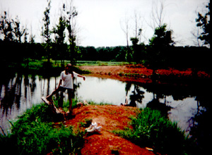 Two 10-acre lakes
,the Upper and Lower Lakes,now support largemouth bass and pan fish. The Upper Lake has been
compared to marginal Wetland habitat and is visited by Canada geese annually. The Lower Lake is spring fed and the water is capable
of supporting trout. In the near future we hope to try to release them. The lands
surrounding the lakes now serve as Wildlife Preserves.
Two 10-acre lakes
,the Upper and Lower Lakes,now support largemouth bass and pan fish. The Upper Lake has been
compared to marginal Wetland habitat and is visited by Canada geese annually. The Lower Lake is spring fed and the water is capable
of supporting trout. In the near future we hope to try to release them. The lands
surrounding the lakes now serve as Wildlife Preserves.
With almost 8 sq. miles of forest
, we are still mapping the tree stands and trails. And where the old villages stood. Since many
haul roads, even narrow ones 4 feet wide for ox carts, were made with 4" crushed rock, they are still quite usable today.